Gone and Back Again


I stayed two days at a nondescript rv park in Henderson Nevada, which is just south of Las Vegas on the Boulder Highway. My site was supposed to be empty and ready for me, but it wasn’t. It was noon when I arrived, and I’m pretty sure the occupants weren’t awake yet. By 1 pm, water and electric was unhooked, and they were rolling away without apology.

I used this time to do laundry, shower several times,, resupply, and, of course, roast coffee. There was nothing very remarkable about the rv park, so I won’t name it. Most of the residents were year round and long-term. Lots of the Rv’s were older and in need of repair, even though the park supposedly had a ten-year rule in order to stay there. By that, if your rv was older than ten years from the date of manufacturer, keep looking. I fibbed about the date on my rv (since Scamp hasn’t changed it’s design since about 1978, mine looks as new as the ones coming from the factory now), but I didn’t feel too bad after seeing the motley assortment of ancient trailers that somehow found their way into their spots. Maybe they were grandfathered?

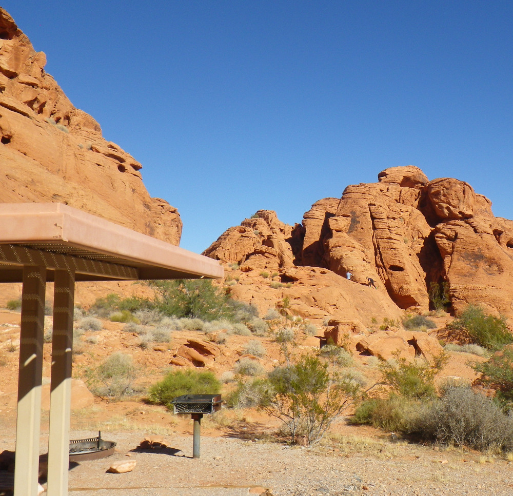
Anyway, I am back to Valley of Fire. I arrived late morning, which seems like a good time because there were only a few rigs present when I arrived. By evening it was nearly full.  The Brew Hut didn’t move far—merely across the gravel road where solar is more ample, and the views more generous behind the campsite.

The days are getting shorter. I’m sleeping in until nearly 7 a.m., and it’s pretty much dark by 7 p.m. Since Julia arrives on Sunday, I’ve been brushing up on my pancake operations in the morning. It makes for a nice sweet treat to start the day with my fresh roasted Papua New Guinea coffee.

T-mobile doesn’t live here in the campground, but I’ve found a few places where one or two bars of signal can be had, so I’ve been able to pick up my daily local newspaper to read with breakfast. Elvis and I usually have our 12k-15k steps by noon. During the afternoon, I’ve been reading John Muir’s “My First Summer in the Sierra.” I was worried it might not be accessible, but he’s an excellent writer and communicator, probably due to his Wisconsin roots.

I’ve been scavenging firewood from campsites that people have departed from—with some success. I hope to have a few fires this week to lengthen the short days. I also found the Overton library (Moappa Valley Public Library), and it’s free wifi connection, so I downloaded some more Netflix to watch during the evenings. I’m pretty settled into my routine, but I’m sure that Julia will shake me out of that shortly.


Valley of Fire


I’ve been traveling for over a month, but I finally find my happy space: Valley of Fire State Park, which is about an hour northeast of Las Vegas, Nevada. There are two campgrounds here. One is for the big rv’s and has electric hookups. The other is called Arch Rock and is for small Rvs and tents with no electric hookups. There’s nothing luxurious about my campsite, except for the million dollar views. I do have close water, garbage cans, and vault toilets. Ample solar tops off the batteries in two or three hours of late morning/early afternoon sun. And, drum roll, dogs are allowed on the trails.

Valley of Fire is Nevada’s largest and most popular state park. You do have to be a bit lucky to get one of the first come, first serve campsites here. Campsites rarely stay open long (usually filling in minutes even mid-week), and the campground has always been full by mid-afternoon with a sign out front indicating “campground full”. I’m always amazed at the optimistic people who circle through from mid-afternoon until after dark, hoping that the sign lies. It does lie in the morning when early risers break camp, but the sign tells no lies after 3 p.m.


People who know me well understand that I’m easily entertained, sipping my early evening IPA while watching the procession of hopeful campers pass through. This is indeed a case of the early bird gets the worm.

Elvis and I have been hiking in the mornings before it gets warm. In the full sun on the red rock, it does get hot. I carry water for us both. By noonish, we are settled under our shade structure at the campsite. By 3 p.m., the natural shadows from the huge towers of rock behind our campsite project natural shade for the late afternoon and early evening.


Spoiled by our water spigot for doing dishes, I’ve been making apple (from the Pipe Spring orchard) and banana pancakes in the morning, and branching out in the evening with steaks, beans and rice, and pasta dishes with sausage. Evenings are cold IPA’s and perhaps a nightcap of ginger ale on the rocks (sometimes with a splash of bourbon).


There is no reason to move from here, except a 14 day camping limit within a 28 day period. In order for Julia to enjoy the area on the 21st, I’m going to have to vacate my campsite for a few days and hope to be a lucky early bird to get another campsite secured for the both of us. I feel like I understand the rhythm of how people leave and go from this place, but we will see how that works out. Until then, I’m just going to enjoy the moment, the quiet, the unbelievable night skies, and the rocks.


Virgin River Recreation Area


From Pipe Springs National Monument, I drove west towards Hurricane, Utah. My plan was to disperse camp in the Hurricane, Utah area near Zion National Park. That didn’t work out. As I drove, I was checking out the access roads out to federal land. I didn’t see any roads that I wanted to drive out on, especially without knowing whether or not I could get turned around. Then I saw Sheep Bridge Road, a well-known boondocking spot that I had read about on Campendium and freecampsites.net.

I did a U-turn at the pull-off spot just past Sheep Bridge and pulled down into the road and past the bridge. So far, so good. The road was hard packed gravel. As I approached the first pull-off, I observed a van covered in red mud and deep tire ruts where they had pulled in. I wasn’t sure how they were going to get out again, but it didn’t look good. I passed several other better turn-outs, but those were already occupied by campers, and a few not-so-good turnoffs were also occupied, even though driving through mud and water was necessary to get to the spots.

I continued driving on the washboard roads at about 5 mph until I saw a left turn that didn’t look promising. I continued on, but didn’t see any more spots or places to turn around. I ended up backing up the Brew Hut several hundred yards to get turned around again. Then I drove back out with my tail between my legs (Elvis understood) and got back on the main road. Sheep Bridge Road wasn’t happening.

I had another dispersed camping spot on my possibles list, but it required driving to the Virgin Dam—about an hour away. There were only a few campsites reported at that location, and I just wasn’t in the mood to drive that far to find out that they were occupied too. More rain was forecast for that night, and conditions weren’t going to improve. I did a little more research in St. George, and found a couple of possible free sites towards Nevada.

Just as I crossed from Utah to a narrow strip of Arizona, I saw a brown sign proclaiming Virgin River Recreational area just off I-15. It seemed worth a stop and look. Sure enough, it was a BLM campground for only $8/night, beautiful mountains all around (despite the dark sky), flush toilets, running water, no hookups, but beautiful views. I pulled into a site overlooking the Virgin River and settled in.


I was more than a little surprised that this campground was over half-full when I arrived and completely filled by evening to the point that people were illegally camped in the picnic area below the next morning. Elvis and I hiked the campground loops several times, hung out at our picnic table overlooking the muddy river and mountains, hiked down to the river from the campground, and then tried to hike a trail leading from the picnic area below.


The trail was supposed to be 16 miles long, but we were stopped after less than a mile by a muddy river and fast-moving current. I don’t know if there are times of the year where the trail crosses a shallow or dry riverbed, but this wasn’t one of those times.


Elvis and I went back to the Brew Hut, where I cooked a thin sirloin steak to medium rare with mushrooms, onions, and toasted sourdough bread. I drank a bottle or two of Elysian Space Dust IPA (one of my new favorites), while Elvis ate dog food and licked my dinner plate as dessert (and pre-rinse before doing dishes). It rained for most of the evening and while I slept, but in the morning the sun was breaking apart the clouds. After granola with yogurt, I made coffee for the road. We were headed for Valley of Fire State Park.


Pipe Spring National Monument


I have never been so interested and depressed about a national monument.


I am camped at a nice rv park owned and operated by the Kaibob Band of Paiute Indians. I was running out of coffee, so it was time for electricity hookups to roast coffee, and to take the opportunity to do laundry, shower, etc.  I’ve discovered that rv parks in the west are parking lots, but some are better than others.


This one distinguishes itself by the lack of lights in the campground, which I appreciate greatly, making for better sleeping at night. Of course, the absence of lights did not help when someone activated their vehicle alarm at 1:30 a.m.

As at most national parks and monuments, dogs are not allowed on the trails at Pipe Spring National Monument. Elvis appreciated the nice footpath going out to the convenience store in one direction and  to the Head Start school building in the other direction.


After duly exercising Elvis, I let him nap in the Brew Hut while I checked out the National Monument, took a tour, and hiked the short trail.  Everything about Pipe Spring is about the water.  I talked to a local Paiute in the gift shop, and she told me that her people had lived in this area since the days of the mammoth.  They were a nomadic people, and moved from place to place, putting little strain on the natural resources.

Then the Mormons came in the 1800’s, and decided that the spring made a perfect place for a cattle operation.  The native rice grass produced flour and sustenance for Paiutes for hundreds of years. The Mormons and their cattle destroyed the native grasses in little more than ten years, according to our ranger guide.


The Mormons produced cheese and butter in great quantities and built a fort around the spring, preventing access to the Paiutes unless they converted to Mormonism or worked like slaves in support of the Mormon operation.

This did not go over well. The Paiutes resisted, driving off the Mormons livestock.  The Mormons formed a militia.  Lives were lost on both sides.  The Paiute’ population was decimated by starvation. After about forty years of overgrazing, the Mormons abandoned the property. Today, about 300 Kaibob Paiutes live in the area.  However, this isn’t the end of the story; the tragedy is still unfolding.  Agricultural and development interests continue to tap the aquifer.  A  hydrologist informed the Park Service that the spring will soon go dry.  The aquifer has maybe 20-30 years left before it’s gone.  Then the farmers, park service, developers, and Paiutes will all be up the dry aquifer without a paddle.

Elvis and I enjoyed a colorful sunrise before the rain clouds moved in.


It’s raining as I write, and more rain is predicted tomorrow when I leave this area and continue to head west.  I would like to disperse camp near Hurricane or Virgin, but we will see what the access roads look like.

Navajo National Monument


After leaving Monticello, Utah in the rain, I drove through Blanding and Bluff, two areas that looked worth exploring if the weather had cooperated.  I kept driving until I passed the Arizona border  I knew that I was in Arizona because the roads immediately turned to crap.  Hwy 191 in Utah had been very good, but the same highway in Arizona possessed holes, dips, and bumps.  Additionally, I sat for thirty minutes waiting for my turn to cross a one lane bridge on a two lane highway with traffic backed up for miles in both directions.


Oh well, what else was there to do in the rain?  I stopped in Medicine Hat for cheaper Arizona gas at higher octane.  Most of the “regular gas” in Wyoming and Utah was 85 octane, compared to Wisconsin’s 87.  I drove past all the fast food restaurants in Kayenta without stopping and continued another 20 miles to Navajo National Monument.

The weather was still dismal:  rainy and cold.  I put on my fleece sweater and cooked up some hot split pea soup, ham and a refried bean burrito.  Then I sat at my dinette with a glass of wine and watched a downloaded movie on Netflix.
On the next morning, the potential for solar power and topping off my battery did not look promising.


However, by ten a.m., things were looking better.


In fact, it warmed up enough that I ended up sitting in my folding chair in the sun and reading for most of the morning.  I also met a fellow camper “Joe” whose base is Harlan, Iowa.  Small world, as my mother grew up in the same small town.

In the afternoon, I hiked the 3 short trails at the Monument.  Although the views are spectacular, what i like best is the wonderful fragrances in the pinion and juniper forest. With a high of 65 degrees at 7200 feet in elevation, the wonderful smell of mountain air (without any smoke), and the promise of more sunshine, this was a place that I could stay for a few days.


It also didn't  hurt that camping is free here for up to 14 days:  paved Rv campsite, flush toilets, garbage services, and running water.  I didn’tt stay for two weeks, but a few days sounded nice.


Moab to Monticello, Utah


Sandy Flats was a great campsite, but I was ready for a change.  The “Alcove” campground was busy, and most of the people were there to ATV or do motor sports.  And everyone seemed to have an off-leash dog that wanted to compete for Alpha designation with on-leash Elvis.

Plan one was to disperse camp along Potash Road west of Moab about 50 minutes.  That plan didn’t work out.  The pavement turned to gravel and then to dirt.  Then the dirt road climbed steeply enough that I began to spin my wheels in two-wheel drive.  Okay, four-wheel drive would work.  The next big problem is that the few dispersed sites had steep drop-offs on the side of the road.  Although the Nissan is four-wheel drive and relatively high-clearance, the Brew Hut is not.  I wasn’t going to make it safely over that gap without scraping the bottom and my waste tank outlets.

The next problem was turning around because there were no turnarounds.  I walked ahead a mile and saw a couple of chances.  I took one of them, but as I backed the trailer, it tipped precariously at the edge of the drop-off.  I got it back on the road and did about a 50 point turnaround to get back headed the other way.

The very first spot had a minimal drop-off, and a big flat wide area to camp, but there was a huge motor home already there who had staked out the area for himself, including some huge foreign (Scandinavian?) flag on a big pole, establishing sovereignty.  I moved to the other side of the flat area and began setting up.  As I was leveling up,  Mr. Motorhome came out and asked why I had to camp so close.  I explained that I had been unable to cross the road gaps to the other sites.  He was having none of it.  “There are all kinds of sites up there,” said Mr. Motorhome who took the easy site and hadn’t been up the road, except in his tow-behind jeep.  I gave up easily and left the scene of Mr Motorhome’s claimed territories.

I drove back to the pavement and pulled in to a BLM (Bureau of Land Management) campground across from the Corona Arch Trailhead.  It was a nice 7-site campground with a host who kept the place clean and quiet.  The rate was $15 that day, but going up to a new rate of $20 the next day.  The host advised me to pay ahead if I wanted the old rate.  I paid for one night and kept the Brew Hut hitched up.

Speaking of the Brew Hut, my trip into the gravel and dirt roads, along with the precarious turn-around, trashed everything.  Screws and hinges came undone.  Granola cereal spilled from the pantry all over the floor.  The small amount of water in my kitchen washtub landed on my sleeping bag when the washtub decided to jump out of the sink. Sorry, there are no pictures.  It was not a scene rated for family viewing.

After cleaning things up and screwing things back in, Elvis and I sat outside the Brew Hut, sipped beverages, and took it easy.  I actually wanted to hike the trailhead across the road, but the temperatures were above 90, and it didn’t seem like a good idea.  The plan was to hike it early in the morning.  Then we woke to rain on the next day, so it was time to go.

We drove back to Moab and then south to Monticello, Utah, where we checked in during the rain at about 8:30 a.m.  I don’t know if I’ve been slumming it at other rv parks, but the Mountain View RV park in Monticello had the best bathrooms I’ve ever been in.  Private, clean, large, heated, and with unlimited hot water for the shower,  I think I was in there for at least an hour, washing away the hot, red dust from four days in Moab.  I did chores, cooked a medium-rare New York strip on the cast iron skillet, along with onions, mushrooms and sourdough bread., and had a couple of glasses of red Zinfandel.


My site was far enough from the road to be relatively quiet and  backed up to horses grazing.  Speedy wi-fi, good water, and a place to dump tanks.  The town of Monticello didn’t have a lot to offer in terms of looking around, but Elvis and I walked from the north end of town to the south end of town in between rain showers.

Rain and cold are forecast for the rest of the week.  We are going to continue south to the Arizona border and perhaps beyond before circling our way back into southern Utah.

Homeward Bound

We are on our way home after spending a couple of days with my mother in Cedar Rapids.   The goal is to put some significant miles on each d...